MILAM COUNTY TEXAS WEBSITE

Present Day Milam County
Welcome to the Milam County website. This is a work in progress so visit often and send us your stories and old photographs.

SUMMARY
In the 1820s, Milam County was organized as the �Municipality of Milam� covering roughly one sixth of the entire state of Texas.
In the 1850's and 1860's, Milam County was subdivided to form several other Texas Counties.
Present day Milam County includes portions of the Brazos, San Gabriel, Brushy Creek and Little Rivers within 1,017 square miles of the Blackland Prairie and Post Oak Savannah regions of Texas.
Towns in present day Milam County include: San Gabriel, Thorndale, Rockdale, Milano, Gause, Burlington,
Cameron (county seat) and Davilla.
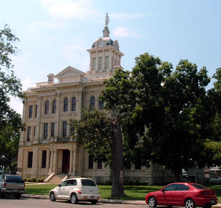
4th Milam County Courthouse in Cameron

Milam County Courthouse Historical Marker in Cameron

Milam County Jailhouse Currently Used as a County Museum
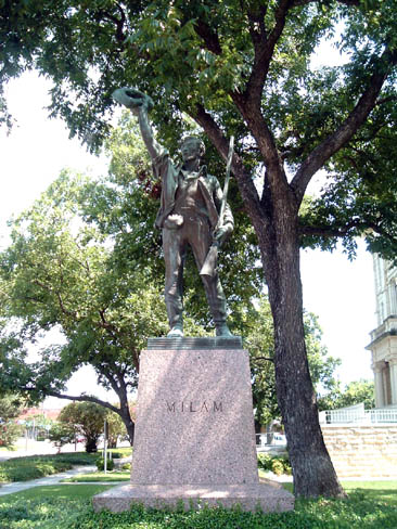
Statue of Ben Milam, the County's Namesake. "Who will follow Old Ben Milam into San Antonio"? was Ben Milam's stirring battle cry that motivated the Texans into battle against the Mexican troops in the 1830's.

Mural on Building in Cameron, County Seat of Milam County

Historic Episcopal Church in Cameron, Milam County

Historical Marker in Front of Episcopal Church in Cameron, Milam County
This is a work in progress and we'll need your stories and photos to keep the site growing.
MILAM COUNTY AREA BULLETIN BOARD
This is a work in progress. Send me your inquires and I'll post them here for our readers.
Thanks.
Leonard Kubiak of Rockdale
History of Milam County, Texas
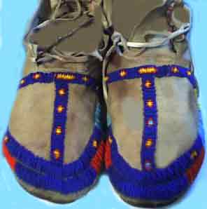
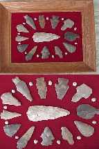
The original inhabitants of the region that became known as Milam County were Native Americans belonging to the Lipan Apache, Tonkawa and Comanches tribes.
Excavations of site camps indicate the presence of Native Americans back as far as 12,000 years ago.
Spanish Colonization of Milam County Region in mid 1700'sMH4>
Spanish Missions Established in Milam County region in Mid 1700's
Next, the Spanish Friars established three Missions along the San Gabriel River in 1746. Anglo-American settlers began arriving in 1834.
By the 1500's, the region was home to several nomatic Indian tribes including the Yeagues, the Huecos, the
caddos, the Lipan Apaches, and Tonkawas. European exploration of the present-day Milam County region, began in
the early 1700's. Fr. Isidro Felix de Espinosa and Domingo Ram�n crossed the San Gabriel and Little rivers in
1716, when the Spanish sent expeditions to hold Texas against the possibility of French settlement. The Spanish
also established several missions along the San Gabriel River, in an effort to Christianize the Indians in the region:
San Francisco Xavier de Horcasitas, which was built in 1746, and San Ildefonso and Nuestra Se�ora de la
Candelaria, which were built in 1749.
A Texas historic marker that stands overlooking the mission site reads, "Established by Franciscan missionaries in 1749 with the hope of civilizing and
christianizing the Coco, Mayeye, Orcoquiza, Karankawa, and other tribes of
Indians. The martyrdom of Padre Jose Ganzabal and the circumstances
connected therewith caused the departure of the Indians and the friars and the
removal of this mission to the San Marcos River in 1755. Reestablished in 1762
on the San Saba River for the conversion of the Lipan Apaches with the new
name of Mission Santa Cruz de San Saba".
Disease and unfriendly Indians caused the Spanish to abandon the sites in
the mid-1750s. The Tonkawa Indians were generally friendly toward missionaries in the eighteenth and settlers in
the early nineteenth centuries, but the nearby Apaches and Comanches presented a constant threat.
Milam County was organized in 1836
Milam County was organized in 1836 as one of the original twenty-three counties of Texas. Situated in Central Texas on the edge of the East Texas timbered region, it has both level prairies with black waxy loam and rolling hills, some with deep, white sandy loams with red clay underliner. Milam County has three main rivers: the Brazos on the east side, Little River through the center and the San Gabriel through the southern portion which is also fed by Brushy Creek just to the west of Rockdale.
The banks of these rivers are lined with cottonwood, sycamore, elm, pecan, and hackberry trees along their banks. Above the river bottoms, Milam County is covered with a wide variety of oak trees.
Early Day Milam County Visitors
Travelers on the El Camino Real (Old San Antonio-Nacogdoches Road), soldiers, missionaries and settlers looking for land, frequently wandered into the present area of Milam County and were repeated attacks by hostile Indians.
Harassed by fierce Apaches, hounded and martyred by autocratic and debased military officers, ravaged by disease, the formerly friendly Indians began to disappear.
Soon after Mexico won her independence from Spain in 1821, a group in Tennesseans sent Robert Leftwich to Mexico to secure a grant of land for colonization. Three years later he received permission to bring eight hundred families to the area above the San Antonio Road which included all of present Milam County. Sterling C. Robertson became the empresario, but various circumstances delayed colonization and created dissension between everyone involved.
The grant was transferred to Stephen F. Austin and Sam Williamson and controversy became even more bitter. The contract was transferred back and forth between Robertson and Austin several times until the beginning of the Texas Revolution, confusing the legality of the land titles of early settlers who began to settle along the Brazos River in the southern portion of the colony.
In 1830 Mexico established a military post called Tenoxtitlan on the Brazos near the Old San Antonio-Nacogdoches Road to protect the frontier, but withdrew the troops in 1832. A village which had grown up around it contained about a dozen families, six of them Anglo-American and six Mexican. In the summer of 1834 an influx of immigrants from Tennessee, Kentucky, Mississippi and Louisiana came to the colony.
Two other towns were established at that time, both on the Brazos, which remained the easiest trade and immigration route. Nashville was founded on the west side of the river two miles below the mouth of Little River, near the present Gause. The village consisted of a cedar log blockhouse and a few log and frame houses. For a little while this was the location of Robertson's headquarters.
The community became a place for incoming settlers to rest, restock their supplies, seek out suitable homesteads and apply for titles. During the periodic Indian raids, the blockhouse provided security and a small cannon to reinforce their guns.
The "falls of the Brazos" was the site of the second settlement, located a few miles south of present Marlin. It was first called Sarahville of Viesco after Robertson's mother and the governor of Mexico. It now became the capital of Robertson's Colony. The population was mostly temporary; like Nashville, it was mainly a way-station for newly arrived immigrants.
Robertson's Colony was organized as the Mexican Municipality of Viesco as early as 1830, but after the death of Benjamin Rush Milam who was killed leading the Texans' attack on the Alamo on December 5, 1835, the Texas Provisional Government changed the name of the municipality and the town of Viesco to Milam in his honor.
During the Texas Revolution the settlers were caught in the worst stages of the "runaway Scrape" of 1836, a general exodus of the colonists before the advance of Santa Anna�s Mexican army after the fall of the Alamo. The settlers of the southern portion of the region made their way through rain and mud, over roads choked with families, livestock and loaded carts to Clapp's Crossing on the Trinity River. Here rumors reached them that Sam Houston's Texas army had been annihilated and the few remaining men among the refugees hastily began erecting log breastworks for defense. With the arrival of couriers with the news of the Texas Victory at San Jacinto on April 21, 1836, the settlers began their return to Nashville.
The settlers in the northern portion had not gone to the Trinity, but had sought protection at Parker's Fort on the Navasota River in present Limestone County. After the families had returned to their homes; they received news that in June Comanche warriors had massacred all the inhabitants of the fort except for several children who were kidnapped, one of whom was Cynthia Ann Parker.
Warned of a coming attack on their village, the colonists again loaded up their household goods, rounded up their livestock and headed south towards Nashville. The Indians caught them on the way, but they escaped with the loss of two men and survived numerous other hardships to finally reach the town. Not one white person remained in the region north of Nashville for many months. A few finally ventured forth, but frequently had to flee to Nashville for protection from the Indians, returning to their cabins when the danger had passed.
Milam County During the Republic of Texas Days

In the 1820s, Milam County was organized as the �Municipality of Milam� covering roughly one sixth of the entire state of Texas.
With the defeat of Santa Anna's army at San Jacinto in April of 1836, Texas became a republic.
The First Congress of the Republic in 1836 named Milam County one of the original seven Texas counties. Later, fifteen counties were carved out of the original Milam County along with parts of eighteen additional counties.
Milam county was named in honor of Benjamin Rush Milam. Benjamin Rush Milam, born in Kentucky 1788, served as a soldier in the War of 1812 and came to Texas
in 1818 where he traded with the Texas Comanche Indians. In 1820, Ben Milam was a Colonel in the Long Expedition
and served as an Empresario of Mexico from 1826 to 1835.During the Texas revoilution, Benjamin Rush Milam participated in
the capture of Goliad, October 9, 1835 was eventually killed in San Antonio on December 7,
1835 while commanding the Texas forces which captured the town from Mexican soldiers.
"Who will follow Old Ben Milam into San Antonio"? was Ben Milam's stirring battle cry that motivated the Texans into battle against the Mexican troops.
The battle between white settlers and the native americans that called the area home continued throughout the days of the Replic and up through the Civil War days.
In the mid to late 1830s, a
company of Texas Rangers was assigned to guard the Milam County area from further Indian attacks. They constructed a blockhouse at the falls of the Brazos and called it Fort Milam. Later, another fort was garrisoned at the three forks of Little River. In the meantime, almost every community had built its own blockhouse. One each at Nashville, Tenoxtitlan and Milam, as well as the one A.W. Sullivan built on the Brazos north of Nashville in the late 1830's and a blockhouse and stockade built by Benjamin Bryant on Little River, about six miles west of present Buckholts, to protect his trading post.
In October 1844, at the falls of the Brazos, a treaty was made with the Indians that fixed a line of demarcation between the Indians and the settlers. It helped somewhat, but as late as January 1845, Indians continued to hunt on Brushy Creek and Little River in violation of the treaty.
MILAM COUNTY SPLIT UP (1850)
From the vast territory of Robertson Colony as defined in the original Spanish grant in the 1820's and renamed Milam County, all or part of 36 present-day counties have been carved.
First, all land east of the Brazos was de-annexed. A number of changes took place in the early 1840's and the area was greatly reduced during the years of early statehood. In 1850, Bell, McLennan and Falls County were created and a final definition of the Milam-Bell County line on April 4, 1861, left the boundaries of Milam County as they are today.
CAMERON SELECTED AS MILAM COUNTY SEAT
A place for a permanent county seat was chosen by seven commissioners to be in a grove of post oaks a mile and a half east of Little River on the Daniel Munroe League. The new seat of justice and government was named Cameron in honor of Ewen Cameron, a member of the Mier Expedition who was captured and shot by the Mexicans. He was said to have bared his breast to the firing squad and shouted, 'I will show you how a brave American can die."
Cameron has remained the county seat and four courthouses have been built there. The two story brick courthouse burned April 9, 1874 and all the archives were destroyed except a few case records and one volume of surveyor's records. It was a major loss to local history.
4th Milam County Courthouse in Cameron
Milam County Courthouse Historical Marker in front of the Courthouse in Cameron
By the late 1840's, now that clear titles to the land and more protection from the Indians were available, immigration increased rapidly and existing colonists were hard-pressed to supply new settlers farm products until they could raise their own crops. Insects, drought and flooding rivers were ongoing problems for farmers for many years.
As late as 1875 transportation in Milam County was by wagons and stagecoaches. In 1861 the Houston and Texas Central Railroad reached Millica, fifty miles east of Cameron, in Brazos County. Produce from Milam moved through this town to Galveston and Houston. The Brazos and Little Rivers were navigated to some extent prior to the Civil War. A steamboat line was established on the Brazos, with wharves for receiving cargo at Port Sullivan, where the Austin-East Texas, and Waco-Houston roads met.
In 1850, the steamboat WASHINGTON brought a consignment of merchandise up Little River to a point near Cameron for Cameron merchants, McCown and Company. It was the only steamboat to ever navigate Little River.
In 1876 the first railroad was completed through the county when the International and Great Northern built a line from Hearne to Austin, crossing the southern portion of Milam County. Trade immediately centered along the railroad, making Rockdale the largest town in the region during the 1870's and 1880's. In addition to the railroad, it was in the center of a coal field which was mined during this period. Thorndale, Gause and Milano, (formerly Milam), also became important trading points because they were on the railroad line. The old towns along the old river trade routes on the Brazos dwindled away and disappeared.
Cameron was cut off from the railroad until 1881, when the Gulf, Colorado and Santa Fe completed a line connecting it with the coast and Fort Worth. In 1890, a third line, the San Antonio and Aransas Pass gave Rockdale its second railroad and three new communities, Ben Arnold, Burlington, and Minerva grew up along this line.
MILAM COUNTY SCHOOLS ESTABLISHED IN 1848
The first attempt at a free school system in Milam County was made in 1848 and the first high school was the Port Sullivan Male and Female College, established in the 1850's. By 1871 there were schools at Jones Prairie, Maysfield, Cameron and Davilla. By 1881, Rockdale also had a free school system.
This is a work in progress. Come back often and send me your stories and old pictures and I'll post them on the
web.
Leonard Kubiak, 1264 FM 2116, Rockdale, Texas 76567.
EARLY DAY SCENES OF MILAM COUNTY TOWNS
For some great early-day postcard scenes across Milam County see the following website:
Milam County Sheriff's Office Website

Copyright � 1996, 1997, 1998, 1999, 2000, 2001, 2002, 2003,2004, 2005,2006. All rights
reserved by Leonard Kubiak, Cedar Park, Texas 78630. Fort Tumbleweed and forttumbleweed are trasdemarks of Leonard Kubiak. No Part of this Website nor any of
it's contents may be
reproduced in any manner without written permission of lenkubiak.geo@yahoo.com
Web design by Len Kubiak lenkubiak.geo@yahoo.com
 For questions or comments, send me an Email at lenkubiak.geo@yahoo.com For questions or comments, send me an Email at lenkubiak.geo@yahoo.com
MORE PLACES TO GO
Don't forget to bookmark our site and come back often!! Thanks for visiting!!
Click on the deer to add
This Page To Your list of webpage Favorites.

COME BACK TO SEE US OFTEN!
|
Copyright � 1996, 1997, 1998, 1999, 2000, 2001, 2002, 2003, 2004, 2005, 2006, 2007, 2008, & 2009. All rights
reserved by Leonard Kubiak. Fort Tumbleweed and forttumbleweed are trademarks of Leonard Kubiak. No Part of this Website nor any of it's contents may be
reproduced in any manner without written permission.
|

Return to the Fort Tumbleweed Home Page
|