HISTORY OF APACHE PASS, MILAM COUNTY, TEXAS

By Leonard Kubiak, Texas Historian and Long Time Resident of the Apache Pass Area


San Gabriel River flowing through Milam County
APACHE PASS AREA BULLETIN BOARD
Send me your Apache Pass area stories,old photos, and email inquiries and I'll add them to the webpage.
My email address is lenkubiak.geo@yahoo.com and my phone number is 512 630-4619
Leonard Kubiak
Indians of Milam County
The earliest immigrants to Milam County were called Paleo People who moved as nomadic bands with extended families of perhaps two dozen individuals, including grandparents, descendants, in-laws and a few children. Over time, their bands scattered widely, throughout the Americas and some postulate they became the Aztec Indian nation in Mexico. These paleo families took shelter where they could find it, like cliff overhangs or caves. They used animal skins for clothing and gathered food by foraging, driving big game herds over cliffs and harvested and cooked edible plant seeds, roots and fruits.
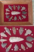
The Paleo people made stone tools, using "flint knapping," or stone chipping, techniques similar to those of ancient people in northeastern Siberia to shape raw flint and chert into crude chopping, cutting, gouging, hammering and scraping tools. They fashioned other crude tools, including pointed implements, from the bones of animals. They used flat milling stones to process plant foods, grinding seeds, for example, into flour.
Their most powerful weapon was the throwing stick called the Atlatls and a short spear equipped with flutted flint spears capable of bringing down Ice Age mastodons, mammoths, long-horned bison, horses, camels and giant sloths. Fossilized remains of these ice age mammals are found all along the San Gabriel and Little Rivers in Milam County.
The best known paleo spear points were the Clovis and Folsom points (named after the sites in New Mexico where they were first discovered). The Clovis point with fluted sides,was first discovered, in association with Ice Age animals, at the famous Paleo-Indian Blackwater Draw site in eastern New Mexico, a few miles south of the city of Clovis. Possibly the oldest of the known Paleo-Indian spear tips, the 12,000- to 15,000-year-old Clovis points have been found across the northern hemisphere.
Folsom points, similar to the Clovis points but generally smaller, were first discovered, in association with Ice Age bison bones, in northeast New Mexico, near the small community of Folsom. About 10,000 years old, Folsom points have been found in Milam County.
We may never be sure of when or how the Paleo-Indians came to Milam County or what routes they followed across the continents. We can do little more than guess about such things as their beliefs, their spirituality, their celebrations, their rituals, their medicines, their mournings, their music, their dance, their band structures, their language, their family relationships or their child rearing. The Paleo-Indians, who finally faded from the American scene some 8000 to 9000 years ago, are likely to remain as elusive as shadows in the night in American archaeology (unless we're right that they became the Aztec Nation).
They were followed by the hunters and gatherers who built campsites all along the San Gabriel River for thousands of years. One of the early tribes in the region were the Tonkawas.
The Tonkawa Indians, who numbered in the thousands, in what became Milam County, included the following tribes: the Rancheria Grande, the Yojuane, the Mayeye, and the Ervipiame.
The Yojuane tribe, like most of the native american tribes, were a mobile tribe frequently moving their camps between the Colorado River of modern day Travis County and the Brazos River and points in-between. Many of these tribes followed the buffalo herds which provided much of their food, clothing and shelter needs.
The Lipan Apaches became neighbors of the Tonkawas sometime after 1300. By the eighteenth century the Caddo, the Tehuacana, and the Waco Indians and a composite group, which the Spanish called the Rancher�a Grande, also frequented the area.
European exploration of what would become Milam County began in the early eighteenth century. Fr. Isidro Felix de Espinosa and Domingo Ram�n crossed the San Gabriel and Little rivers in 1716, when the Spanish sent expeditions to hold Texas against the possibility of French settlement. The Spanish also established several missions along the San Gabriel River, in an effort to Christianize the Indians in the region: San Francisco Xavier de Horcasitas, which was built in 1746, and San Ildefonso and Nuestra Se�ora de la Candelaria, which were built in 1749. Disease and unfriendly Indians caused the Spanish to abandon the sites in the mid-1750s. The Tonkawa Indians were generally friendly toward missionaries in the eighteenth and settlers in the early nineteenth centuries, but the nearby Apaches and Comanches presented a constant threat.
HISTORY OF APACHE PASS, MILAM COUNTY, TEXAS
Apache Pass was the name given by early Spanish explorers to the major Lipan Apache trail across a gravel bar on the San Gabriel River northwest of present-day Rockdale. This trail was attributed to the Lipan Apaches that moved into the region in the 1700's.

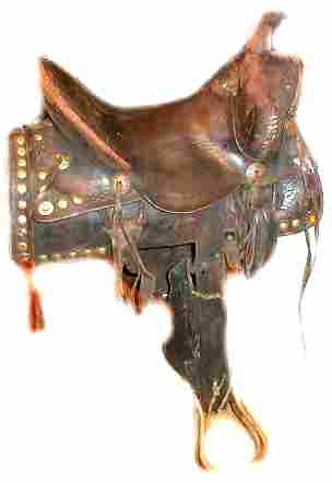
Early Day Apache Camp in Texas
The name Apache most probably came from the Zu�i word apachu, meaning "enemy," or possibly Awa'tehe, the Ute name for Apaches. The Apaches referred to themselves as Inde or Din�, meaning "the people." Historians are in general agreement that Apaches arrived in the Southwest between A.D. 1000 and 1400.
The Lipan and Mescalero were the two major bands of Apache that reached present day Texas. The early Spanish explorers described the Apaches as hunters and gatherers with a focus on bison hunting.
The Apache were knowlegable farmers and developed advanced systems of irregation.
With the arrival of more and more Comanche Indians in Texas, the Lipan Apache came under attack causing the Apache to turn to the Spanish Missions for help against the Comanche.
SPANISH EXPLORATION OF APACHE PASS AREA (1700's)
European exploration near what would become Milam County, Texas began in
the early 1700's. Fr. Isidro Felix de Espinosa and Domingo Ram�n crossed the San Gabriel and Little rivers in
1716, when the Spanish sent expeditions to hold Texas against the possibility of French settlement.
The Spanish
established three missions along the San Gabriel River near what is now called Apache Pass. These missions include:
Mission San Xavier de los Dolores (also known as San Francisco Xavier Mission was completed in 1748)
Mission San Ildefonso was completed in 1749
Mission Nuestra Senora de la Candelaria was completed in 1749

Texas historic marker installed in 1936 identifies the site of Mission San Ildefonso built in December of 1749 near Apache Pass off present-day FM 908.

Texas historic marker installed in 1936 identifies the site of Mission San Francisco Xavier de los Dolores built in 1748 on the south banks of the San Gabriel River on the North side of FM 908.

Texas historic marker installed in 1936 identifies the site of Mission Nuestra Senora de la Candelaria built in 1749. The marker is located off County Road 408.
The mission marker reads, "Established by Franciscan missionaries in 1749 with the hope of civilizing and
christianizing the Coco, Mayeye, Orcoquiza, Karankawa, and other tribes of
Indians. The martyrdom of Padre Jose Ganzabal and the circumstances
connected therewith caused the departure of the Indians and the friars and the
removal of this mission to the San Marcos River in 1755. Reestablished in 1762
on the San Saba River for the conversion of the Lipan Apaches with the new
name of Mission Santa Cruz de San Saba".
The missions were under the protection of a garrison of soldiers
One of the San Xavier missions was founded by the College of Santa Cruz de Quer�taro under the leadership of Father Mariano Francisco de los Dolores y Viana. It was on the south bank of the San Gabriel River .
San Francisco Xavier de Gigedo Presidio was established near the mission in 1751 and housed a garrison of fifty soldiers. A crisis emerged when the garrison severely beat some Coco Indians when they entered the presidio with his weapons. As a result of the beating, the Cocos fled Mission Candelaria. Father Pinilla requested some soldiers attempt to bring the Cocos back, but Captain R�bago replied that he was sick and could not go. R�bago did send four soldiers who returned almost immediately, saying they could not find or follow the trail of the two hundred Coco Indians who left the mission.
During it's final four years in existance, Mission Candelaria was occupied intermittently by Bidais, Orocoquisas, and Coco Indians. The San Gabriel River location was finally abandoned in 1755 after a severe drought and epidemic which struck Indian, soldier and priest alike. On August 16, 1755, the population of Candelaria was moved to another mission on the San Marcos river. The presidio was moved at the same time, and the Spanish missions of Milam County ceased to exist.
Lipan Apaches continued to live in Milam County and in
1836, switched their allegiance from the Spanish to the Republic of Texas to fight the Comanches. In 1846, the US annexed Texas. As Comanche attacks weakened during the 1850s, American settlers pushed the Lipans, their former allies and protectors, off their traditional lands.
In the 1870s the U.S. Army killed or imprisoned virtually all of the remaining Lipan Apache in and survivors were sent to the Mescalero reservation in New Mexico. THE LIPAN APACHE NATION TODAY
In 1873, President Grant signed the Executive Order establishing the Mescalero Reservation in southeastern New Mexico near Ruidosa. Today, the Mescalero Reservation is the �official� home of both the Lipan and the Mescalero. This reservation constituted a small fraction of the large region that the Mescalero and Lipan had previously occupied, but it was, at least, within their traditional lands. Over the next century, their people faced great challenges�extreme poverty, epidemics, military attacks, and intrusions from white settlers.
In the early twentieth century, Lipan Apache from Mexico were brought to the reservation; still others who had been interned at Fort Sill, Oklahoma, were brought to the reservation in 1913.
Some Apache bands had settled in northern Mexico while those in the United States were placed on a series of reservations. The Fort Sill Apache Reservation in Oklahoma mostly held displaced Chiricahua Apache (part of the western Apache) although a few Lipan also resided on that reservation. The White Mountain Apache in Arizona are largely descended from the Gila Apache while the Jicarilla Apache of the Southern Plains descend from the Faraones. They were placed on a reservation in northern New Mexico.

Painting of a Lipan Apache camp by artist, George Nelson. By this time, the Apache had horses and had switched to teepees covered with heavy buffalo hides. (Image courtesy of the Institute of Texan Cultures, University of Texas at San Antonio).

Theodore Gentilz made this painting of a Lipan Apache camp in the 1840s near present-day Medina County, where he was surveying land for new townsites.

Comanches Moved into the Rockdale Region in the early 1800's and remained a threat to white settlement in the region until the 1840's.
Relationship of Apache Pass to El Camino Real de los Tejas
Apache Pass was a major Native American and early day settler crossing on the San Gabriel river. It is a site where the wagon tracks across the San Gabriel River are still in evidence.
Apache Pass is one of dozens of Native American trails through central Texas that were merged into the El Camino Real de los Tejas (The Royal Road to the Tejas). This trail crossed Mexico and the present-day states of Texas and Louisiana. This Spanish royal road (parts of which are also called the Old San Antonio Road) was initially established to link Mexico City with Los Adaes, the provincial capital of Texas from 1722 to 1772. Approximately 2,500 miles long, this trail of changing routes from Mexico City to the Red River Valley was traveled for over 300 years.
In October of 2004, the United States Congress brought the El Camino Real de los Tejas National Historic Trail into the National Trails System Act of 1968 to be administered by the National Park Service. Thus the El Camino Real joins a system of national historic, scenic, and recreational trails crossing the United States.
The route of the Camino de los Tejas through Milam County is described in a book by Al McGraw and others, A Texas Legacy: The Old San Antonio Road and The Caminos Reales. In this book, McGraw notes that the trail entered present-day Milam County north of Thrall at Detmold.
The trail then went to Apache Pass, then northeast crossing Little River between its confluence with the San Gabriel and the FM 1600 Crossing. The trail then leads toward Cameron, passing near the present day airport. The road forks in Milam County near Apache Pass with a portion of it going through Rockdale and Gause.
The Old San Antonio Road was also known as the Camino Real, the King's Highway, and the San Antonio-Nacogdoches Road. The blazing of the trail came about as the result of three expeditions. In 1690 Alonso De Le�n led his fourth expedition into Texas, this time with the objective to establish San Francisco de los Tejas Mission in East Texas (in the future Houston County). In 1691 Domingo Ter�n de los R�os, first provincial governor of Texas, crossed the Rio Grande taking additional missionaries to the East Texas missions. Up to the R�o Hondo, Ter�n followed much the same course as traveled by De Le�n. During the journey he diverted his path to send a party to Matagorda Bay to meet supply ships. In 1693 Gregorio de Salinas Varona became the first man to proceed directly from the Rio Grande to the East Texas missions, in an expedition to bring relief supplies; he thus further defined the course of the road as a direct route from Monclova, then capital of the province, to the Spanish missions. In 1714 Louis Juchereau de St. Denis probably followed at least part of the road from Natchitoches to San Juan Bautista on the Rio Grande.
In Spanish Texas the Old San Antonio Road was a major artery for travel into Texas. It served as a lifeline for the missions by enabling the transport of freight supplies and military protection, and it facilitated trade. During the eighteenth century Spanish ranchers conducted cattle drives along the route from points in Texas to the annual fair in Saltillo, Coahuila. In addition to being an avenue of commerce, the road enabled immigration. Moses Austin traversed the trail en route to San Antonio to request an empresario grant from the Spanish government in 1820, and many Anglo-American colonists entered Texas at Gaines Ferry on the Sabine and arrived at Nacogdoches and the interior of Texas over the road.
The Old San Antonio Road is best described as a network of trails, with different routes used at different times. Feeder roads branched off the main course. Considerable portions of the route probably existed before the Spanish arrived. Some of the earliest segments of the road were previously links between Indian settlements. Other segments of the road did not appear until much later. The portion connecting Bastrop and Crockett, for example, did not come into use until after 1790, relatively late in the road's history. During the course of the eighteenth century the route between the Rio Grande and San Antonio was gradually shifted southeastward, probably as a result of the Apache and Comanche threat to Spanish travelers.
|


 Rockdale Country Crafts
 History of Milam County
 History of Port Sullivan
 Country Estate Auctions in Rockdale and Caldwell